Hiking Maps and Directions
- demonicdreamz
-
 Topic Author
- Offline
Less
More
- Posts: 856
- Thank you received: 1
17 years 1 month ago - 15 years 4 months ago #1
by demonicdreamz
Hiking Maps and Directions was created by demonicdreamz
Maps and directions to various North Jersey hiking trails.
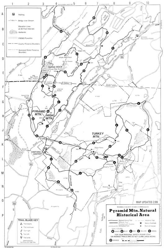
Pyramid Mountain aka Tripod rock
Getting There
Take the I-287 to exit 44, then drive west to the center of Boonton. Turn right onto Route 511 North and go a few miles. There are very few signs pointing to the park but once you take a quick right and left on the road, start looking to your left. After two roads are laving the 511, you'll come across a small parking lot in front of the park's visitor's center. The parking lot is hopelessly small, so you may end up parking on the side of the main road.Only thing I want to add is across from the parking lot is an industrial park called "Mars Park". Big sign, cant miss it.
Please Log in or Create an account to join the conversation.
- demonicdreamz
-
Topic Author
- Offline
Less
More
- Posts: 856
- Thank you received: 1
17 years 1 month ago - 15 years 4 months ago #2
by demonicdreamz
Replied by demonicdreamz on topic Hiking Maps and directions
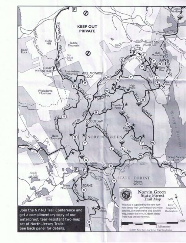
Stone Living room
Getting there
To find the stone living room , coming from Bloomingdale, head for Glenwild Ave in West Milford. If you're coming from West Milford, find Otterhole Rd. Park at the parking lot by the "Welcome To West Milford" sign. Cross the street and follow the blue trail up the mountain. The hike is rugged and will likely take 30 minutes, so bringing liquid refreshment is a good idea.
Please Log in or Create an account to join the conversation.
17 years 1 month ago - 15 years 4 months ago #3
by misterpat
Replied by misterpat on topic Hiking Maps and directions
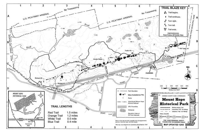
Mount Hope Historical Park.
80west to 34b, 15 north. After the gas station on the right, make your next right. Thats Richard Mine Road. Then follow the attached trail map.
80west to 34b, 15 north. After the gas station on the right, make your next right. Thats Richard Mine Road. Then follow the attached trail map.
Please Log in or Create an account to join the conversation.
17 years 1 month ago - 15 years 4 months ago #4
by misterpat
Replied by misterpat on topic Hiking Maps and Directions
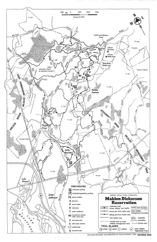
Mahlon Dickerson
80 east/west to route 15 north. Exit Weldon Road. Follow attached trail map.
80 east/west to route 15 north. Exit Weldon Road. Follow attached trail map.
Please Log in or Create an account to join the conversation.
17 years 1 week ago - 15 years 4 months ago #5
by misterpat
Replied by misterpat on topic Hiking Maps and Directions
Ringwood State Park Blue Trail
Please Log in or Create an account to join the conversation.
17 years 1 week ago - 15 years 4 months ago #6
by misterpat
Replied by misterpat on topic Hiking Maps and Directions
Ringwood State Park Yellow Trail
Please Log in or Create an account to join the conversation.
Less
More
- Posts: 443
- Thank you received: 0
16 years 6 months ago - 15 years 4 months ago #7
by hidinginshadows
Follow Macopin up hill for approximately 2 miles and make a left onto Northwood Drive. Parking is to the right.
Facing the Kiosk, trailhead is to left (Lat:41.02534 Lon:-74.37393)
Summary: Enter woods on white trail. After about 5 minutes you will see the green trail come in from the left, going down hill. Turn left here. Trail soon ascends on a woods road, then levels out for about a mile. You'll come to a pond and a large dam. Turn left staying on the green trail as it descends, follows a stream, passes some ruins and huge, rusted tanks, then crosses stream and continues on a woods road. Waterfalls on left. Pay attention here as trail leaves road to right and begins a steep climb, eventually reaching some outstanding overlooks. A short bushwack brings even more views.
Trail then descends gradually, reaches a gravel road then turns back into the woods after a short distance, then crosses a stream. Eventually you come to an intersection with a yello trail. Stay left on the green, follow it to the white trail, turn right on the white and back to your car.
Highlights: Outstanding views and interesting ruins in this relatively unknown area
Near: Bloomingdale, NJ
Scenery:
Distance: 4 miles round trip
Elevation Gain: 600 ft
Hike Time: 2 hours
Difficulty: Moderate
Trail Condition: OK, but a few difficult spots
HikeType: Loop
Replied by hidinginshadows on topic Apshawa Preserve
Apshawa Preserve
Route 287 to exit 53 (Bloomingdale). Go west on Hamburg Turnpike. Follow through town and just before small bridge make a right onto Macopin Rd.Follow Macopin up hill for approximately 2 miles and make a left onto Northwood Drive. Parking is to the right.
Facing the Kiosk, trailhead is to left (Lat:41.02534 Lon:-74.37393)
Summary: Enter woods on white trail. After about 5 minutes you will see the green trail come in from the left, going down hill. Turn left here. Trail soon ascends on a woods road, then levels out for about a mile. You'll come to a pond and a large dam. Turn left staying on the green trail as it descends, follows a stream, passes some ruins and huge, rusted tanks, then crosses stream and continues on a woods road. Waterfalls on left. Pay attention here as trail leaves road to right and begins a steep climb, eventually reaching some outstanding overlooks. A short bushwack brings even more views.
Trail then descends gradually, reaches a gravel road then turns back into the woods after a short distance, then crosses a stream. Eventually you come to an intersection with a yello trail. Stay left on the green, follow it to the white trail, turn right on the white and back to your car.
Highlights: Outstanding views and interesting ruins in this relatively unknown area
Near: Bloomingdale, NJ
Scenery:
Distance: 4 miles round trip
Elevation Gain: 600 ft
Hike Time: 2 hours
Difficulty: Moderate
Trail Condition: OK, but a few difficult spots
HikeType: Loop
Please Log in or Create an account to join the conversation.
Less
More
- Posts: 32
- Thank you received: 0
16 years 3 months ago - 15 years 4 months ago #8
by captainspunk17
Replied by captainspunk17 on topic Hiking Maps and Directions
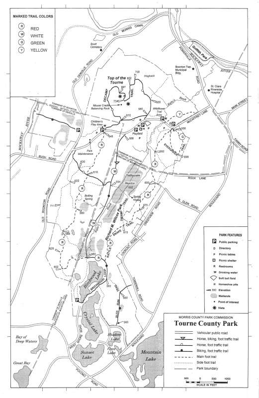
The Tourne Park in Morris County. It covers 547 acres of land and is in Denville, Booton, and Mountain Lakes. It has awesome views, especially in the fall when the leaves are changing colors. There are hiking, biking, and equestrian trails. It's a very nifty place. My Nan used to take me all the time when I was little. And in the winter they allow sledding. It's a great place you should check it out!
www.morrisparks.net/maps/HiRes/TournePark.jpg
www.morrisparks.net/maps/HiRes/TournePark.jpg
Please Log in or Create an account to join the conversation.